


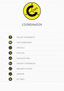
Coordinator-Collect Coordinate

Mô tả của Coordinator-Collect Coordinate
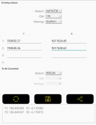
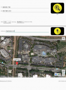
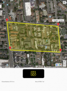
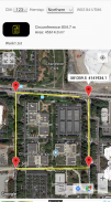
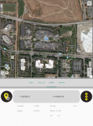
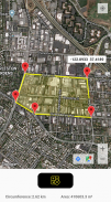
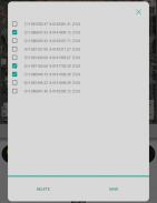
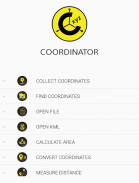
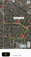
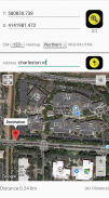
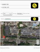
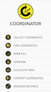
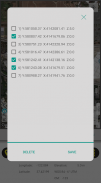
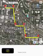
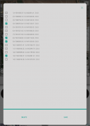
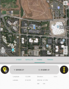
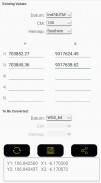
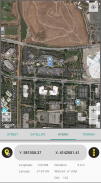
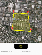
Sử dụng ứng dụng Điều phối viên, bạn có thể thu thập dữ liệu tọa độ từ đất liền trên bất kỳ hệ tọa độ nào bạn muốn, lựa chọn từ các hệ thống đã xác định. Bạn có thể thu thập tọa độ GPS. Bạn có thể sử dụng ứng dụng làm công cụ theo dõi GPS. Bạn có thể xem dữ liệu tọa độ trên bản đồ và cũng có thể tìm kiếm theo địa chỉ và xem dữ liệu đó trên bản đồ. Bạn có thể nhận được hướng dẫn đến điểm đó. Bạn có thể tìm kiếm theo kinh độ / vĩ độ. Bạn có thể chuyển đổi một tọa độ hiện có thành một hệ tọa độ khác. Bạn có thể thực hiện việc này bằng cách nhập tọa độ theo cách thủ công hoặc mở tệp XLSX có chứa tọa độ. Bạn có thể hiển thị số đo chu vi và diện tích của một số tọa độ bằng cách mở tệp đã tạo trước đó. Ngoài ra, bạn có thể đo khoảng cách và diện tích cho một số tọa độ được xác định thủ công trên bản đồ. Bạn có thể hiển thị tệp KML trên bản đồ. Ngoài ra còn có một công cụ la bàn. Ứng dụng Điều phối viên chứa một số công cụ hữu ích cho những người quan tâm đến tọa độ, bản đồ và hệ thống thông tin địa lý (GIS).
Tất cả các tính năng trên đều miễn phí.
Mặt khác, nếu bạn trở thành người đăng ký Coordinator Pro, bạn có thể được hưởng lợi từ nhiều tính năng bổ sung ngoài các tính năng này. Với Coordinator Pro, người đăng ký có thể sử dụng một số tính năng bổ sung như Chức năng cơ sở dữ liệu đám mây (tạo điểm, đường & đa giác, chia sẻ lớp của bạn với đồng đội, làm việc đồng thời với đồng đội, làm việc ngoại tuyến và đồng bộ hóa, v.v.), xuất sang tệp KML & Excel, làm truy vấn độ cao và địa chỉ, v.v. Nó không có quảng cáo.
Bên cạnh kinh độ / vĩ độ, người đăng ký có thể tìm ra giá trị độ cao của một điểm trên bản đồ. Bạn có thể tìm kiếm theo địa chỉ và định vị nó trên bản đồ và tìm hiểu giá trị tọa độ GPS (kinh độ / vĩ độ hoặc hướng đông bắc / kinh độ) của địa điểm này. Tính năng định vị địa chỉ hoạt động dựa trên các dịch vụ bản đồ và nó rất hiệu quả.
Nếu bạn là người đăng ký, bạn có thể sử dụng ứng dụng Web Điều phối viên. Vì vậy, bạn có thể sử dụng các tính năng cơ sở dữ liệu đám mây của ứng dụng Điều phối viên trên trang web trên máy tính của bạn và theo dõi dữ liệu ngay lập tức. Bạn có thể xem / theo dõi và chỉnh sửa dữ liệu cơ sở dữ liệu đám mây trên trang web. Bằng cách này, bạn có thể theo dõi tức thì các chuyển động dữ liệu được thực hiện trong ứng dụng di động tại hiện trường, trong trình duyệt web trên máy tính của bạn.
Hệ tọa độ của các quốc gia mà ứng dụng được tải xuống nhiều nhất, được thêm vào ứng dụng.
Danh sách hiện tại của các quốc gia và hệ thống tọa độ của họ được xác định trong ứng dụng này:
Thế giới - GPS (WGS 84)
Thế giới - WGS 84 - 6 ̊ UTM
Hoa Kỳ - "Hệ thống tọa độ mặt phẳng trạng thái HARN NAD 1983 (mét & feet)" và "Hệ thống tham chiếu lưới quân sự (MGRS)"
Algeria - "Nord Sahara 1959 / UTM 6 ̊"
Azerbaijan - "Pulkovo 1942 / Gauss-Kruger 3 ̊" và "Pulkovo 1942 / CS63"
Bulgaria - "Pulkovo 1942 (58) GK 6 ̊"
Đức - "DHDN / 3 ̊ GK" và "ETRS89 UTM 6 ̊"
Ấn Độ - "Kalianpur 1975 / India" và "Kalianpur 1975 / UTM 6 ̊"
Indonesia - "Indonesia 1974 UTM 6 ̊" và "DGN 1995 Indonesia TM3 ̊"
Iran - "ED50 (ED77) / UTM 6 ̊"
Iraq - "Nahrwan 1967 / UTM 6 ̊" và "ED50 / Iraq National Grid" và "Karbala 1979 / UTM 6 ̊"
Israel - "Palestine 1923 / Palest. Grid" và "Palestine 1923 / Israel CS Grid" và "Israel 1993 / Israel TM Grid"
Lebanon - "Deir ez Zor / Levant Ster." và "Deir ez Zor / Syria Lambert"
Mauritania - "Mauritania 1999 / UTM 6 ̊"
Maroc - "Merchich / Nord Maroc" và "Merchich / Sud Maroc"
Hà Lan - "Amersfoort / RD Mới" và "Amersfoort / RD Cũ"
Palestine - "Palestine 1923 / Palest. Grid" và "Palestine 1923 / Israel CS Grid" và "Israel 1993 / Israel TM Grid"
Philippines - "Luzon 1911 / Philippines" và "PRS92 / Philippines"
Romania - "Dealul Piscului 1930 / Stereo 33" và "Pulkovo 1942 (58) / Stereo 70"
Nga - "Pulkovo 1942 / Gauss-Kruger 3 ̊"
Ả Rập Xê Út - "Ain el Abd / UTM 6 ̊" và "Ain el Abd / Aramco Lambert"
Syria - "Deir ez Zor / Levant Ster." và "Deir ez Zor / Syria Lambert"
Thổ Nhĩ Kỳ - "ITRF 96 - 3 ̊" và "ED 50 - 3 ̊" và "ITRF 96 - 6 ̊" và "ED 50 - 6 ̊"
Các Tiểu vương quốc Ả Rập Thống nhất - "Nahrwan 1967 / UTM"
Coordinator-Collect Coordinate - Phiên bản 7.8.2
(21-06-2025)
Coordinator-Collect Coordinate - Thông tin APK
Phiên bản APK: 7.8.2Gói: com.suleymaner.coordinatorplusPhiên bản mới nhất của Coordinator-Collect Coordinate
Phiên bản khác


Ứng dụng cùng danh mục


Bạn cũng có thể thích...


